
Mapa topográfico North Paravur
Mapa interativo
Clique no mapa para exibir a altitude.
Sobre este mapa
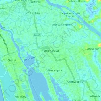
Nome: Mapa topográfico North Paravur, altitude, relevo.
Altitude média: 5 m
Altitude mínima: -3 m
Altitude máxima: 23 m
Paravur is located at 10.14° N 76.7° E[1]. It has an average elevation of 10 metres (32 feet). The town is situated at north end of Ernakulam district and bordering with Thrissur district. The towns in Thrissur district like Kodungallore, Mala, Chalakudy and the towns Kalamassery, Aluva, Angamaly, Vypin island are located near to this town. The Paravur Taluk lies in the flat delta region of the Periyar river and cut by several canals, which have resulted in the formation of many islands. The Kodungalloor Kayal (backwaters) and Varappuzha Kayal (backwaters) are in this taluk. The town and neighboring areas were deeply affected by floods in 2018 due to heavy rain.
Outros mapas topográficos
Clique em um mapa para visualizar sua topografia, sua altitude e seu relevo.
Kottuvally
India > Kerala > Paravur > Valluvally
Kottuvally, Valluvally, Paravur, Ernakulam District, Kerala, India
Altitude média: 5 m
Puthenvelikara Pond
India > Kerala > Paravur > Puthenvelikkara
Puthenvelikara Pond, Puthenvelikkara, Paravur, Ernakulam District, Kerala, India
Altitude média: 7 m
Alangad
India > Kerala > Paravur > Thirumuppam
Alangad, Thirumuppam, Paravur, Ernakulam District, Kerala, India
Altitude média: 6 m
Karumalloor
India > Kerala > Paravur > Manjaly
Karumalloor, Manjaly, Paravur, Ernakulam District, Kerala, India
Altitude média: 7 m
Puthenvelikkara
India > Kerala > Paravur > Puthenvelikkara
Puthenvelikkara, Paravur, Ernakulam district, Kerala, 683594, India
Altitude média: 6 m
Koonammavu
Koonammavu, Paravur, Ernakulam District, Kerala, 683518, India
Altitude média: 5 m
Chendamangalam
Chendamangalam, Paravur, Ernakulam District, Kerala, 683512, India
Altitude média: 5 m
Sathar island
India > Kerala > Paravur > Maliankara
Sathar island, Maliankara, Paravur, Ernakulam district, Kerala, India
Altitude média: 4 m