
Mapa topográfico Saale
Mapa interativo
Clique no mapa para exibir a altitude.
Sobre este mapa
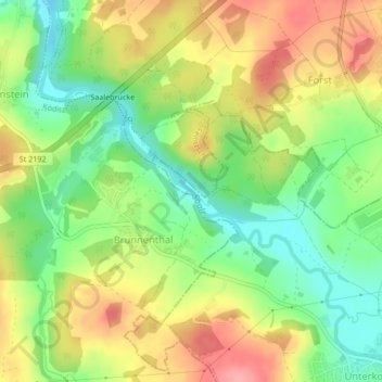
Nome: Mapa topográfico Saale, altitude, relevo.
Local: Saale, Hof, Bayern, 95030, Deutschland (50.34689 11.87397 50.35049 11.87994)
Altitude média: 505 m
Altitude mínima: 457 m
Altitude máxima: 557 m
Outros mapas topográficos
Clique em um mapa para visualizar sua topografia, sua altitude e seu relevo.
Rosenbühl
Deutschland > Bayern > Hof > Osseck
Rosenbühl, Osseck, Hof, Bayern, 95030, Deutschland
Altitude média: 539 m
Unterkotzau
Deutschland > Bayern > Hof > Unterkotzau
Unterkotzau, Hof, Bayern, 95030, Deutschland
Altitude média: 509 m
Osseck
Deutschland > Bayern > Hof > Osseck
Osseck, Hof, Bayern, 95030, Deutschland
Altitude média: 551 m
Alsenberg
Deutschland > Bayern > Hof > Alsenberg
Alsenberg, Hof, Bayern, 95028, Deutschland
Altitude média: 510 m