
Mapa topográfico Eyjafjallajökull
Mapa interativo
Clique no mapa para exibir a altitude.
Sobre este mapa
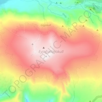
Nome: Mapa topográfico Eyjafjallajökull, altitude, relevo.
Altitude média: 821 m
Altitude mínima: 109 m
Altitude máxima: 1628 m
Eyjafjallajökull (Icelandic: (listen); lit. 'glacier of the mountains of the islands') is one of the smaller ice caps of Iceland, north of Skógar and west of Mýrdalsjökull. The ice cap covers the caldera of a volcano with a summit elevation of 1,651 metres (5,417 ft). The volcano has erupted relatively frequently since the Last Glacial Period, most recently in 2010, when, although relatively small for a volcanic eruption, it caused enormous disruption to air travel across western and northern Europe for a week.
Outros mapas topográficos
Clique em um mapa para visualizar sua topografia, sua altitude e seu relevo.
Eyjafjallajökull
Eyjafjallajökull, Rangárþing eystra, Southern Region, Iceland
Altitude média: 1459 m
Skogafoss
Skogafoss, Rangárþing eystra, Southern Region, Iceland
Altitude média: 145 m