
Mapa topográfico Kwenxura
Mapa interativo
Clique no mapa para exibir a altitude.
Sobre este mapa
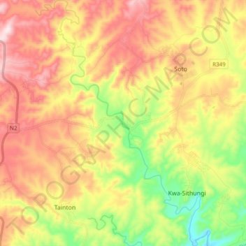
Nome: Mapa topográfico Kwenxura, altitude, relevo.
Altitude média: 236 m
Altitude mínima: 4 m
Altitude máxima: 465 m
Outros mapas topográficos
Clique em um mapa para visualizar sua topografia, sua altitude e seu relevo.
Great Kei Ward 1
RSA > Eastern Cape > Great Kei Local Municipality
Great Kei Ward 1, Great Kei Local Municipality, Amathole District Municipality, Eastern Cape, RSA
Altitude média: 118 m
Great Kei Ward 6
RSA > Eastern Cape > Great Kei Local Municipality
Great Kei Ward 6, Great Kei Local Municipality, Amathole District Municipality, Eastern Cape, RSA
Altitude média: 132 m