
Mapa topográfico Krishnanagar
Mapa interativo
Clique no mapa para exibir a altitude.
Krishnanagar
Krishnanagar is located at 23°24′N 88°30′E / 23.4°N 88.5°E / 23.4; 88.5. The area of the municipality is around 16 km2. It is situated on the southern banks of the Jalangi River. It has an average elevation of 14 metres (46 ft). The Tropic of Cancer passes through the outskirts of Krishnanagar. The latitude of the Tropic of Cancer is 23° 26′ 5″ N.
Sobre este mapa
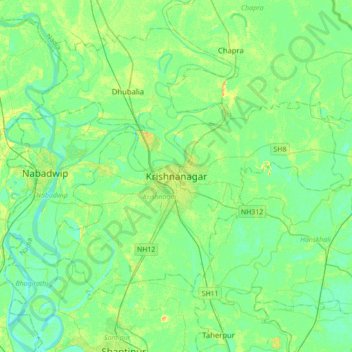
Nome: Mapa topográfico Krishnanagar, altitude, relevo.
Local: Krishnanagar, Krishnagar-I, Nadia, West Bengal, 741101, India (23.24585 88.33589 23.56585 88.65589)
Altitude média: 11 m
Altitude mínima: 3 m
Altitude máxima: 29 m