
Mapa topográfico Abingdon
Mapa interativo
Clique no mapa para exibir a altitude.
Sobre este mapa
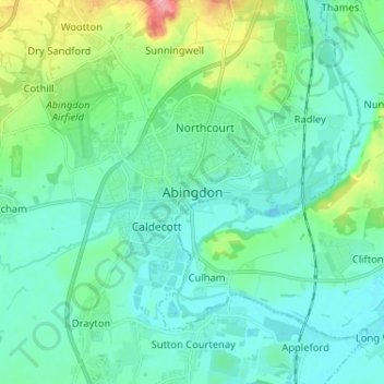
Nome: Mapa topográfico Abingdon, altitude, relevo.
Altitude média: 64 m
Altitude mínima: 45 m
Altitude máxima: 136 m
Outros mapas topográficos
Clique em um mapa para visualizar sua topografia, sua altitude e seu relevo.
Woolstone
United Kingdom > England > Oxfordshire > Vale of White Horse
Woolstone, Vale of White Horse, Oxfordshire, England, United Kingdom
Altitude média: 143 m
Uffington
United Kingdom > England > Oxfordshire > Vale of White Horse
Uffington, Vale of White Horse, Oxfordshire, England, United Kingdom
Altitude média: 138 m
Harwell
United Kingdom > England > Oxfordshire > Vale of White Horse
Harwell, Vale of White Horse, Oxfordshire, England, United Kingdom
Altitude média: 90 m
Milton Heights
United Kingdom > England > Oxfordshire > Vale of White Horse > Milton
Milton Heights, Milton, Vale of White Horse, Oxfordshire, England, OX14 4BG, United Kingdom
Altitude média: 72 m
Harrowdown Hill
United Kingdom > England > Oxfordshire > Vale of White Horse
Harrowdown Hill, Vale of White Horse, Oxfordshire, England, OX13 5ET, United Kingdom
Altitude média: 74 m
Lamborough Hill
United Kingdom > England > Oxfordshire > Vale of White Horse > Dry Sandford > Lamborough Hill
Lamborough Hill, Wootton, Dry Sandford, Vale of White Horse, Oxfordshire, England, OX13 6BY, United Kingdom
Altitude média: 92 m
Wantage
United Kingdom > England > Oxfordshire > Vale of White Horse > Wantage
Wantage, Vale of White Horse, Oxfordshire, South East England, England, United Kingdom
Altitude média: 151 m
Radley
United Kingdom > England > Oxfordshire > Vale of White Horse
Radley, Vale of White Horse, Oxfordshire, England, United Kingdom
Altitude média: 66 m
Watchfield
United Kingdom > England > Oxfordshire > Vale of White Horse
Watchfield, Vale of White Horse, Oxfordshire, England, United Kingdom
Altitude média: 97 m
Vale of White Horse
United Kingdom > England > Oxfordshire > Vale of White Horse
Vale of White Horse, Oxfordshire, South East England, England, United Kingdom
Altitude média: 105 m