
Mapa topográfico Ua Pou
Mapa interativo
Clique no mapa para exibir a altitude.
Ua Pou
It is located about 50 km (30 mi.) south of Nuku Hiva, in the northern Marquesas. The center of the island is characterized by four high basalt pillars that reach high above the surrounding mountains. The highest of these pillars, Mount Oave (Mont Oave), reaches to 1,230 m (4,040 ft) above sea level and is the highest elevation in the Marquesas.
Sobre este mapa
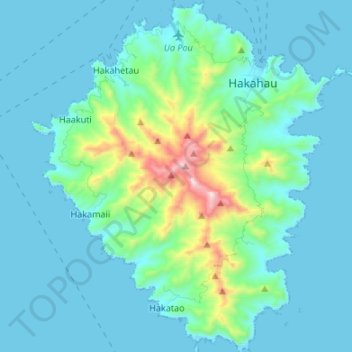
Nome: Mapa topográfico Ua Pou, altitude, relevo.
Local: Ua Pou, Marquesas Islands, French Polynesia, France (-9.46723 -140.13578 -9.33490 -140.01976)
Altitude média: 127 m
Altitude mínima: -4 m
Altitude máxima: 919 m
Outros mapas topográficos
Clique em um mapa para visualizar sua topografia, sua altitude e seu relevo.