
Mapa topográfico Ketchum
Mapa interativo
Clique no mapa para exibir a altitude.
Sobre este mapa
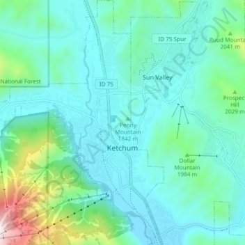
Nome: Mapa topográfico Ketchum, altitude, relevo.
Local: Ketchum, Blaine County, Idaho, United States (43.65955 -114.41189 43.71297 -114.35118)
Altitude média: 1906 m
Altitude mínima: 1742 m
Altitude máxima: 2671 m
After the mining boom subsided in the 1890s, sheepmen from the south drove their flocks north through Ketchum in the summer, to graze in the upper elevation areas of the Pioneer, Boulder, and Sawtooth mountains. By 1920, Ketchum had become the largest sheep-shipping center in the West. In the fall, massive flocks of sheep flowed south into the town's livestock corrals at the Union Pacific Railroad's railhead, which connected to the main line at Shoshone.
Outros mapas topográficos
Clique em um mapa para visualizar sua topografia, sua altitude e seu relevo.
Rocky Butte
United States > Idaho > Blaine County
Rocky Butte, Blaine County, Idaho, United States
Altitude média: 1727 m
Carey
United States > Idaho > Blaine County
Carey, Blaine County, Idaho, 83320, United States
Altitude média: 1467 m
Sun Valley
United States > Idaho > Blaine County
Sun Valley, Blaine County, Idaho, United States
Altitude média: 1988 m
Titus Lake
United States > Idaho > Blaine County
Titus Lake, Blaine County, Idaho, United States
Altitude média: 2736 m
Bellevue
United States > Idaho > Blaine County
Bellevue, Blaine County, Idaho, 83313, United States
Altitude média: 1667 m
Hailey
United States > Idaho > Blaine County
Hailey, Blaine County, Idaho, 83333, United States
Altitude média: 1729 m