
Mapa topográfico Kankakee
Mapa interativo
Clique no mapa para exibir a altitude.
Sobre este mapa
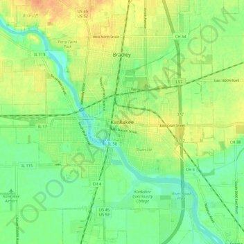
Nome: Mapa topográfico Kankakee, altitude, relevo.
Local: Kankakee, Kankakee County, Illinois, 60901, United States (41.08003 -87.90115 41.16003 -87.82115)
Altitude média: 195 m
Altitude mínima: 178 m
Altitude máxima: 214 m
Greater Kankakee Airport covers an area of 950 acres (380 ha) (384 ha) at an elevation of 629 feet (192 m) above mean sea level. It has two runways with asphalt surfaces: 4/22 is 5,981 by 100 feet (1,823 x 30 m) and 16/34 is 4,398 by 75 feet (1,341 x 23 m).