
Mapa topográfico Bear Mountain State Park
Mapa interativo
Clique no mapa para exibir a altitude.
Sobre este mapa
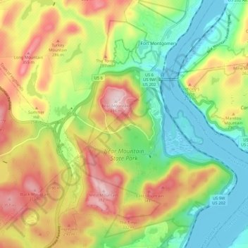
Nome: Mapa topográfico Bear Mountain State Park, altitude, relevo.
Altitude média: 166 m
Altitude mínima: 0 m
Altitude máxima: 394 m
There are over 50 official trails covering 235 miles (378 km), featuring a wide range of difficulties and elevation changes.
Outros mapas topográficos
Clique em um mapa para visualizar sua topografia, sua altitude e seu relevo.
Tomkins Cove
United States > New York > Rockland County > Town of Stony Point
Tomkins Cove, Town of Stony Point, Rockland County, New York, 10986, United States
Altitude média: 68 m
Buckberg
United States > New York > Rockland County > Town of Stony Point
Buckberg, Town of Stony Point, Rockland County, New York, 10986, United States
Altitude média: 108 m
Lake Welch
United States > New York > Rockland County > Town of Stony Point
Lake Welch, Town of Stony Point, Rockland County, New York, United States
Altitude média: 324 m