
Mapa topográfico Caterham
Mapa interativo
Clique no mapa para exibir a altitude.
Sobre este mapa
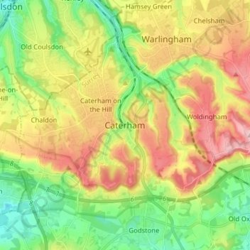
Nome: Mapa topográfico Caterham, altitude, relevo.
Altitude média: 157 m
Altitude mínima: 70 m
Altitude máxima: 270 m
In 1840 Caterham contained a total of 477 residents (figures taken from that census, compiled in an 1848 topographical encyclopedia) and in 1848 468 acres (189 ha) of its 2,386 acres (966 ha) were common land. Similar to today, 175 acres (71 ha) mostly steeper acres were woodland.
Outros mapas topográficos
Clique em um mapa para visualizar sua topografia, sua altitude e seu relevo.
Tandridge District
United Kingdom > England > Surrey > Tandridge District
Tandridge District, Surrey, South East England, England, United Kingdom
Altitude média: 114 m
Nutfield
United Kingdom > England > Surrey > Tandridge District
Nutfield, Tandridge District, Surrey, England, United Kingdom
Altitude média: 88 m
Warlingham
United Kingdom > England > Surrey > Tandridge District
Warlingham, Tandridge District, Surrey, England, United Kingdom
Altitude média: 163 m