
Mapa topográfico Scotts Valley
Mapa interativo
Clique no mapa para exibir a altitude.
Sobre este mapa
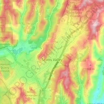
Nome: Mapa topográfico Scotts Valley, altitude, relevo.
Altitude média: 203 m
Altitude mínima: 63 m
Altitude máxima: 332 m
Approximately ten thousand years ago there was a lake in the lowest elevation of Scotts Valley. Archeological excavations of site CA-SCR-177 (Scotts Valley Site) in 1983 and 1987 support dates for human settlement of this area as between 9,000 and 12,000 years before present (YBP). The lake drained during the Mid-Holocene warming period (4,000-5,000 YBP) forming what is now known as Carbonera Creek. When the lake drained, the people moved downslope following the lake water’s transformation as in became the creek. Around 2000 BC, Ohlone people occupied areas along the remaining creeks, spring and seep areas, along with permanent and seasonal drainages, and on flat ridges and terraces. Permanent villages were usually placed on elevations above seasonal flood levels. Surrounding areas were used for hunting and seed, acorn, and grass gathering. Therefore, areas along watercourses are considered likely locations for prehistoric cultural resources. Several watercourses, including portions of Carbonera Creek, Bean Creek, and MacKenzie Creek, are within the city.
Outros mapas topográficos
Clique em um mapa para visualizar sua topografia, sua altitude e seu relevo.
Santa Cruz
United States > California > Santa Cruz County
Santa Cruz, Santa Cruz County, California, United States
Altitude média: 89 m
Watsonville
United States > California > Santa Cruz County
Watsonville, Santa Cruz County, California, United States
Altitude média: 117 m
Twin Lakes
United States > California > Santa Cruz County
Twin Lakes, Santa Cruz County, California, United States
Altitude média: 5 m
Swanton
United States > California > Santa Cruz County
Swanton, Santa Cruz County, California, United States
Altitude média: 137 m
Huckleberry Woods
United States > California > Santa Cruz County > Boulder Creek
Huckleberry Woods, Boulder Creek, Santa Cruz County, California, 95006, United States
Altitude média: 263 m
Felton
United States > California > Santa Cruz County > Felton
Felton, Santa Cruz County, California, United States
Altitude média: 230 m
Bald Mountain
United States > California > Santa Cruz County
Bald Mountain, Santa Cruz County, CAL Fire Northern Region, California, 94050, United States
Altitude média: 279 m
Lomond Terrace
United States > California > Santa Cruz County > Ben Lomond
Lomond Terrace, Ben Lomond, Santa Cruz County, CAL Fire Northern Region, California, 95005, United States
Altitude média: 231 m
Soquel
United States > California > Santa Cruz County > Soquel
Soquel, Santa Cruz County, CAL Fire Northern Region, California, United States
Altitude média: 60 m
Boulder Creek
United States > California > Santa Cruz County > Boulder Creek
Boulder Creek, Santa Cruz County, CAL Fire Northern Region, California, 95006, United States
Altitude média: 287 m
Ben Lomond
United States > California > Santa Cruz County
Ben Lomond, Santa Cruz County, CAL Fire Northern Region, California, 95005, United States
Altitude média: 210 m
Bonny Doon
United States > California > Santa Cruz County
Bonny Doon, Santa Cruz County, CAL Fire Northern Region, California, 94050, United States
Altitude média: 367 m
Corralitos
United States > California > Santa Cruz County > Corralitos
Corralitos, Santa Cruz County, California, 95976, United States
Altitude média: 166 m
Aptos
United States > California > Santa Cruz County > Seacliff
Aptos, Seacliff, Santa Cruz County, California, United States
Altitude média: 114 m