
Mapa topográfico Whitehorse
Mapa interativo
Clique no mapa para exibir a altitude.
Sobre este mapa
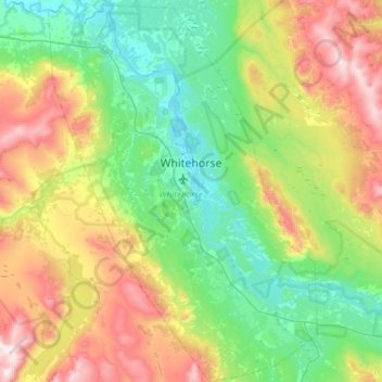
Nome: Mapa topográfico Whitehorse, altitude, relevo.
Local: Whitehorse, Yukon, Canada (60.55364 -135.27872 60.84619 -134.85673)
Altitude média: 1007 m
Altitude mínima: 629 m
Altitude máxima: 1857 m
Whitehorse has a subarctic climate (Köppen climate classification: Dfc) and lies in the rain shadow of the Coast Mountains, causing precipitation totals to be quite low year-round. Due to the city's location in the Whitehorse valley, the climate is milder than other comparable northern communities such as Yellowknife. With an average annual temperature of −0.1 °C (31.8 °F) Whitehorse is the warmest place in the Yukon. The temperature measurements for the city are taken at the airport. The Whitehorse Riverdale weather station situated at a lower elevation than the airport is even warmer at 0.2 °C (32.4 °F).