
Mapa topográfico Huntley
Mapa interativo
Clique no mapa para exibir a altitude.
Sobre este mapa
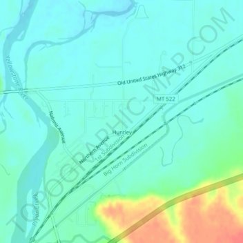
Nome: Mapa topográfico Huntley, altitude, relevo.
Local: Huntley, Yellowstone County, Montana, United States (45.88711 -108.31916 45.91403 -108.29097)
Altitude média: 924 m
Altitude mínima: 911 m
Altitude máxima: 965 m
During the Yellowstone Flood of 1937, the damage to Huntley was more extensive, percentage-wise, than in any other community in the region. Much of the original town of Huntley was destroyed and significant portions of the land it occupied was claimed or compromised by the Yellowstone River. The flood damage included washing away the suspension bridge that allowed adjacent Highway 312 to cross the river. After the flood, the site of the town was relocated from the north side of the river to the higher elevation on the south bank.
Outros mapas topográficos
Clique em um mapa para visualizar sua topografia, sua altitude e seu relevo.
Billings
United States > Montana > Yellowstone County
Billings, Yellowstone County, Montana, United States
Altitude média: 1023 m
Laurel
United States > Montana > Yellowstone County
Laurel, Yellowstone County, Montana, United States
Altitude média: 1019 m
Yegen
United States > Montana > Yellowstone County
Yegen, Yellowstone County, Montana, United States
Altitude média: 981 m