
Mapa topográfico Orléans
Mapa interativo
Clique no mapa para exibir a altitude.
Sobre este mapa
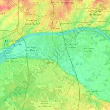
Nome: Mapa topográfico Orléans, altitude, relevo.
Altitude média: 104 m
Altitude mínima: 85 m
Altitude máxima: 133 m
At the end of the 1960s, the Orléans-la-Source [fr] neighbourhood was created, 12 kilometres (7 mi)to the south of the original commune and separated from it by the Val d'Orléans and the river Loiret (whose source is in the Parc Floral de la Source). This quarter's altitude varies from about 100 to 110 m (330 to 360 ft).
Outros mapas topográficos
Clique em um mapa para visualizar sua topografia, sua altitude e seu relevo.
La Maladrerie
France > Centre-Val de Loire > Loiret > Cléry-Saint-André
La Maladrerie, Cléry-Saint-André, Orléans, Loiret, Centre-Val de Loire, Metropolitan France, 45370, France
Altitude média: 94 m
Saran
France > Centre-Val de Loire > Loiret
Saran, Orléans, Loiret, Centre-Val de Loire, Metropolitan France, 45770, France
Altitude média: 122 m
Maimbray
France > Centre-Val de Loire > Loiret > Beaulieu-sur-Loire
Maimbray, Beaulieu-sur-Loire, Montargis, Loiret, Centre-Val de Loire, Metropolitan France, 45630, France
Altitude média: 147 m
Montantaume
France > Centre-Val de Loire > Loiret > Saint-Germain-des-Prés
Montantaume, Saint-Germain-des-Prés, Montargis, Loiret, Centre-Val de Loire, Metropolitan France, 45220, France
Altitude média: 122 m
Vitry-aux-Loges
France > Centre-Val de Loire > Loiret
Vitry-aux-Loges, Orléans, Loiret, Centre-Val de Loire, Metropolitan France, 45530, France
Altitude média: 126 m
Le Malesherbois
France > Centre-Val de Loire > Loiret
Le Malesherbois, Pithiviers, Loiret, Centre-Val de Loire, Metropolitan France, 45330, France
Altitude média: 120 m
Briare
France > Centre-Val de Loire > Loiret
Briare, Montargis, Loiret, Centre-Val de Loire, Metropolitan France, 45250, France
Altitude média: 159 m
Chilleurs-aux-Bois
France > Centre-Val de Loire > Loiret
Chilleurs-aux-Bois, Pithiviers, Loiret, Centre-Val de Loire, Metropolitan France, 45170, France
Altitude média: 129 m
Montereau
France > Centre-Val de Loire > Loiret
Montereau, Montargis, Loiret, Centre-Val de Loire, Metropolitan France, 45260, France
Altitude média: 138 m