
Mapa topográfico Yavapai County
Mapa interativo
Clique no mapa para exibir a altitude.
Sobre este mapa
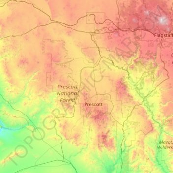
Nome: Mapa topográfico Yavapai County, altitude, relevo.
Local: Yavapai County, Arizona, United States of America (33.88216 -113.33448 35.53065 -111.46127)
Altitude média: 1433 m
Altitude mínima: 345 m
Altitude máxima: 3757 m
The county's topography makes a dramatic transition from the lower Sonoran Desert to the south to the heights of the Coconino Plateau to the north, and the Mogollon Rim to the east. The highest point above sea level (MSL) in Yavapai County is Mount Union at an elevation of 7,979 ft (2,432 m) and the lowest is Agua Fria River drainage, now under Lake Pleasant.
Outros mapas topográficos
Clique em um mapa para visualizar sua topografia, sua altitude e seu relevo.
Maricopa County
United States of America > Arizona
Maricopa County, Arizona, United States of America
Altitude média: 549 m
Darling
United States of America > Arizona > Winona
Darling, Winona, Coconino County, Arizona, United States of America
Altitude média: 1916 m
Pima County
United States of America > Arizona
Pima County, Arizona, United States of America
Altitude média: 807 m