
Mapa topográfico Marlborough
Mapa interativo
Clique no mapa para exibir a altitude.
Sobre este mapa
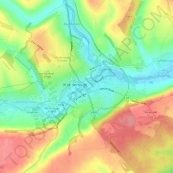
Nome: Mapa topográfico Marlborough, altitude, relevo.
Local: Marlborough, Wiltshire, England, United Kingdom (51.40358 -1.76224 51.43758 -1.70455)
Altitude média: 163 m
Altitude mínima: 122 m
Altitude máxima: 206 m
Marlborough has an oceanic climate somewhat influenced by its inland position and at 407 feet (124 m) elevation is more prone to frost than southern coastal areas. For example, in 1909 the town reported the equal lowest temperature in the UK at a station below 1,600 feet (500 m) for that year, with a temperature of −17.8 °C (0.0 °F) on 3 March.
Outros mapas topográficos
Clique em um mapa para visualizar sua topografia, sua altitude e seu relevo.
Bradford-on-Avon
United Kingdom > England > Wiltshire
Bradford-on-Avon, Wiltshire, England, United Kingdom
Altitude média: 71 m
Devizes
United Kingdom > England > Wiltshire
Devizes, Wiltshire, England, United Kingdom
Altitude média: 118 m
West Amesbury
United Kingdom > England > Wiltshire
West Amesbury, Wiltshire, England, SP4 7BH, United Kingdom
Altitude média: 90 m
Amesbury
United Kingdom > England > Wiltshire > Amesbury
Amesbury, Wiltshire, England, United Kingdom
Altitude média: 103 m
Downton
United Kingdom > England > Wiltshire > Downton
Downton, Wiltshire, South West England, England, United Kingdom
Altitude média: 74 m