
Mapa topográfico St. George
Mapa interativo
Clique no mapa para exibir a altitude.
Sobre este mapa
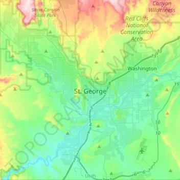
Nome: Mapa topográfico St. George, altitude, relevo.
Local: St. George, Washington County, Utah, United States (37.00000 -113.64976 37.20959 -113.47681)
Altitude média: 929 m
Altitude mínima: 729 m
Altitude máxima: 1497 m
The St. George valley occasionally receives wet or slushy snowfall in the winter, but what accumulates usually melts off by the mid-to-late morning; the normal seasonal snowfall is 1.4 inches (3.6 cm). The earliest snowfall was measured on October 29, 1971, and the latest on April 11, 1927. The record single-day snowfall is 10.0 inches (25 cm) which was set on January 5, 1974. With the city having elevations ranging from 2,500 to about 3,500 feet (760 to about 1,070 m), some areas such as Diamond Valley and Winchester Hills will typically receive more snowfall and colder temperatures than the rest of the lower valley. The most recent major snow event was on December 8, 2013, when between 6.0 and 8.0 inches (15 and 20 cm) virtually shut down the city, making it the third heaviest snowfall in the city's history. Also significant about the storm was how low temperatures dropped and remained that way for several days with daytime highs failing to reach the freezing mark, and one night time low temperature of 1 °F (−17 °C), recorded at the airport, was the coldest in the city in over 100 years. The cold spell killed or severely damaged much of the area's non-native vegetation, such as the Mexican fan palm trees.
Outros mapas topográficos
Clique em um mapa para visualizar sua topografia, sua altitude e seu relevo.
Zion National Park
United States > Utah > Washington County
Zion National Park, Washington County, Utah, United States
Altitude média: 1877 m
Pine Valley
United States > Utah > Washington County
Pine Valley, Washington County, Utah, 84781, United States
Altitude média: 2092 m
Dammeron Valley
United States > Utah > Washington County
Dammeron Valley, Washington County, Utah, 84783, United States
Altitude média: 1444 m
Sand Mountain
United States > Utah > Washington County
Sand Mountain, Washington County, Utah, United States
Altitude média: 1190 m
Toquerville
United States > Utah > Washington County
Toquerville, Washington County, Utah, 84774, United States
Altitude média: 1301 m
Gunlock
United States > Utah > Washington County
Gunlock, Washington County, Utah, 84733, United States
Altitude média: 1210 m
Hildale
United States > Utah > Washington County
Hildale, Washington County, Utah, 84784, United States
Altitude média: 1763 m
Snow Canyon State Park
United States > Utah > Washington County
Snow Canyon State Park, Washington County, Utah, 84738, United States
Altitude média: 1169 m
Pintura
United States > Utah > Washington County
Pintura, Washington County, Utah, United States
Altitude média: 1382 m
Silver Reef
United States > Utah > Washington County > Leeds
Silver Reef, Leeds, Washington County, Utah, 84746, United States
Altitude média: 1185 m
Bee Hive
United States > Utah > Washington County
Bee Hive, Washington County, Utah, 84767, United States
Altitude média: 1651 m
Kolob Reservoir
United States > Utah > Washington County
Kolob Reservoir, Washington County, Utah, United States
Altitude média: 2499 m
Washington
United States > Utah > Washington County
Washington, Washington County, Utah, 84780, United States
Altitude média: 924 m
Virgin
United States > Utah > Washington County > Virgin
Virgin, Washington County, Utah, United States
Altitude média: 1251 m
Mount Baldy
United States > Utah > Washington County
Mount Baldy, Washington County, Utah, United States
Altitude média: 2352 m
Zion Lodge
United States > Utah > Washington County
Zion Lodge, Washington County, Utah, United States
Altitude média: 1722 m
Hurricane Hill
United States > Utah > Washington County > Hurricane
Hurricane Hill, Hurricane, Washington County, Utah, 84745, United States
Altitude média: 1074 m
New Harmony
United States > Utah > Washington County > New Harmony
New Harmony, Washington County, Utah, United States
Altitude média: 1636 m
Hurricane
United States > Utah > Washington County
Hurricane, Washington County, Utah, United States
Altitude média: 1154 m
Pine Valley
United States > Utah > Washington County > Pine Valley
Pine Valley, Washington County, Utah, 84781, United States
Altitude média: 2075 m
Springdale
United States > Utah > Washington County
Springdale, Washington County, Utah, 84767, United States
Altitude média: 1349 m
Bloomington Hill
United States > Utah > Washington County > St. George
Bloomington Hill, St. George, Washington County, Utah, 84770-1858, United States
Altitude média: 810 m
Hurricane
United States > Utah > Washington County > Hurricane > Hurricane
Hurricane, Washington County, Utah, 84745, United States
Altitude média: 1075 m
Central
United States > Utah > Washington County > Central
Central, Washington County, Utah, 84722, United States
Altitude média: 1636 m
Watchman Trailhead
United States > Utah > Washington County > Springdale
Watchman Trailhead, Springdale, Washington County, Utah, 84767, United States
Altitude média: 1316 m
Enterprise
United States > Utah > Washington County
Enterprise, Washington County, Utah, 84725, United States
Altitude média: 1690 m
Ivins
United States > Utah > Washington County
Ivins, Washington County, Utah, 84738, United States
Altitude média: 1007 m
La Verkin
United States > Utah > Washington County
La Verkin, Washington County, Utah, United States
Altitude média: 1117 m
Veyo
United States > Utah > Washington County
Veyo, Washington County, Utah, 84782, United States
Altitude média: 1379 m