
Mapa topográfico Puylaurent
Mapa interativo
Clique no mapa para exibir a altitude.
Sobre este mapa
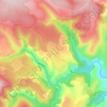
Nome: Mapa topográfico Puylaurent, altitude, relevo.
Altitude média: 1055 m
Altitude mínima: 850 m
Altitude máxima: 1196 m
Outros mapas topográficos
Clique em um mapa para visualizar sua topografia, sua altitude e seu relevo.
Les Huttes
France > Occitanie > Lozère > La Bastide-Puylaurent > La Bastide
Les Huttes, La Bastide, La Bastide-Puylaurent, Mende, Lozère, Occitanie, France métropolitaine, 48250, France
Altitude média: 1088 m
La Bastide
France > Occitanie > Lozère > La Bastide-Puylaurent
La Bastide, La Bastide-Puylaurent, Mende, Lozère, Occitanie, France métropolitaine, 48250, France
Altitude média: 1084 m
Masméjean
France > Occitanie > Lozère > La Bastide-Puylaurent
Masméjean, La Bastide-Puylaurent, Mende, Lozère, Occitanie, France métropolitaine, 48250, France
Altitude média: 1143 m