
Mapa topográfico Kunigal
Mapa interativo
Clique no mapa para exibir a altitude.
Sobre este mapa
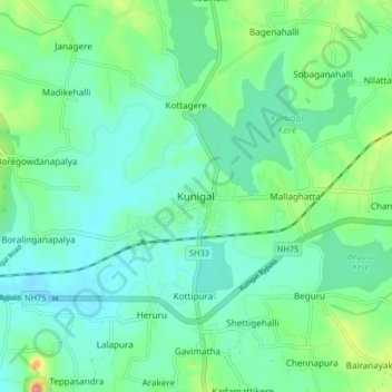
Nome: Mapa topográfico Kunigal, altitude, relevo.
Altitude média: 775 m
Altitude mínima: 751 m
Altitude máxima: 850 m
Kunigal is located at 13°01′N 77°02′E / 13.02°N 77.03°E / 13.02; 77.03. It has an average elevation of 773 metres (2536 feet). It is situated on the National Highway 48 ( NH-48 ) connecting Bangalore and Mangalore and State Highway 33 connecting Tumakuru and Madduru. Recently opened Hassan-Bangalore railway line transverses through Kunigal.
Outros mapas topográficos
Clique em um mapa para visualizar sua topografia, sua altitude e seu relevo.
Sugganahalli
India > Karnataka > Kunigal taluk
Sugganahalli, Kunigal taluk, Tumakuru District, Karnataka, India
Altitude média: 676 m
Ujjani
India > Karnataka > Kunigal taluk
Ujjani, Kunigal taluk, Tumkur district, Karnataka, 572123, India
Altitude média: 717 m