
Mapa topográfico Mayrhofen
Mapa interativo
Clique no mapa para exibir a altitude.
Sobre este mapa
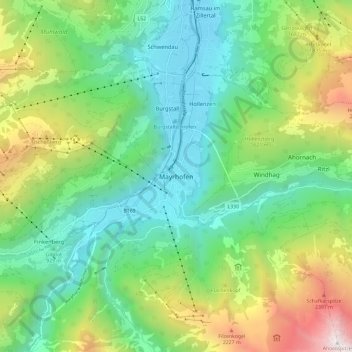
Nome: Mapa topográfico Mayrhofen, altitude, relevo.
Local: Mayrhofen, Bezirk Schwaz, Tirol, 6290, Österreich (47.12722 11.82387 47.20722 11.90387)
Altitude média: 1314 m
Altitude mínima: 584 m
Altitude máxima: 2939 m
Outros mapas topográficos
Clique em um mapa para visualizar sua topografia, sua altitude e seu relevo.
Dristner
Österreich > Tirol > Mayrhofen
Dristner, Mayrhofen, Schwaz, Tirol, 6292, Österreich
Altitude média: 1976 m