
Faça uma doação
Prepare-se para a sua próxima aventura:
Como Associado da Amazon, este site recebe uma comissão sobre compras elegíveis sem custo adicional para si.
Mapa topográfico El Naranjo
Clique no mapa para exibir a altitude.
Faça uma doação
Prepare-se para a sua próxima aventura:
Como Associado da Amazon, este site recebe uma comissão sobre compras elegíveis sem custo adicional para si.
El Naranjo
El Naranjo is located in an extensive area of tropical and semi-tropical mountains and lowlands called La Huasteca after the Indian civilization and people inhabiting the region. The town of El Naranjo is in the foothills of the Sierra Madre Oriental. It received its name because previously an orchard of orange trees (naranjos) was located at the townsite. The municipality consists mostly of forested mountains with elevations of up to 5,000 feet (1,500 m) and valleys cultivated mostly in sugar cane. A large sugar refinery is located in the town of El Naranjo.
Faça uma doação
Prepare-se para a sua próxima aventura:
Como Associado da Amazon, este site recebe uma comissão sobre compras elegíveis sem custo adicional para si.
Sobre este mapa
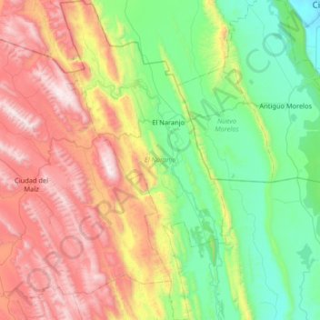
Nome: Mapa topográfico El Naranjo, altitude, relevo.
Local: El Naranjo, San Luis Potosí, Mexico (22.14646 -99.54433 22.74850 -99.20609)
Altitude média: 733 m
Altitude mínima: 82 m
Altitude máxima: 1936 m
Faça uma doação
Prepare-se para a sua próxima aventura:
Como Associado da Amazon, este site recebe uma comissão sobre compras elegíveis sem custo adicional para si.
Outros mapas topográficos
Clique em um mapa para visualizar sua topografia, sua altitude e seu relevo.
San Luis Potosí City
Mexico > San Luis Potosi > Municipio de San Luis Potosí
San Luis Potosí, commonly called SLP or simply San Luis, is the capital and the most populous city of the Mexican state of San Luis Potosí. It is the municipal seat of the surrounding municipality of San Luis Potosí. The city lies at an elevation of 1,864 metres (6,115 feet). It has an estimated population…
Altitude média: 2004 m
San Luis Potosí City
Mexico > San Luis Potosi > Municipio de San Luis Potosí
San Luis Potosí, commonly referred to as San Luis, or by its initials SLP (Otomi: Nmiñ'u), is the capital and the most populous city of the Mexican state of San Luis Potosí. It is the municipal seat of the surrounding municipality of San Luis Potosí. The city lies at an elevation of 1,864 metres (6,115…
Altitude média: 2004 m
Faça uma doação
Prepare-se para a sua próxima aventura:
Como Associado da Amazon, este site recebe uma comissão sobre compras elegíveis sem custo adicional para si.
Faça uma doação
Prepare-se para a sua próxima aventura:
Como Associado da Amazon, este site recebe uma comissão sobre compras elegíveis sem custo adicional para si.
San Luis Potosí City
San Luis Potosí, commonly referred to as San Luis, or by its initials SLP (Otomi: Nmiñ'u), is the capital and the most populous city of the Mexican state of San Luis Potosí. It is the municipal seat of the surrounding municipality of San Luis Potosí. The city lies at an elevation of 1,864 metres (6,115…
Altitude média: 2004 m
Matehuala
Mexico > San Luis Potosi > Matehuala
Matehuala is a city in the Mexican state of San Luis Potosí, situated at an elevation of about 1,500 m. Matehuala is also the municipal seat of the municipality of the same name, located in the northern part of the state, on the border with the southwestern corner of Nuevo León. The municipality of Matehuala…
Altitude média: 1754 m
Faça uma doação
Prepare-se para a sua próxima aventura:
Como Associado da Amazon, este site recebe uma comissão sobre compras elegíveis sem custo adicional para si.
San Luis Potosí City
Mexico > San Luis Potosi > Municipio de San Luis Potosí
San Luis Potosí, commonly referred to as San Luis, or by its initials SLP (Otomi: Nmiñ'u), is the capital and the most populous city of the Mexican state of San Luis Potosí. It is the municipal seat of the surrounding municipality of San Luis Potosí. The city lies at an elevation of 1,864 metres (6,115…
Altitude média: 2004 m
Faça uma doação
Prepare-se para a sua próxima aventura:
Como Associado da Amazon, este site recebe uma comissão sobre compras elegíveis sem custo adicional para si.
Guadalupe de los Faz
Mexico > San Luis Potosi > Matehuala > Guadalupe de los Faz
Altitude média: 1659 m
Faça uma doação
Prepare-se para a sua próxima aventura:
Como Associado da Amazon, este site recebe uma comissão sobre compras elegíveis sem custo adicional para si.
Cerrito de la Cruz
Mexico > San Luis Potosi > Municipio de San Luis Potosí > San Luis Potosí
Altitude média: 1904 m