
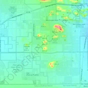
Mapa topográfico Drexel Heights
Mapa interativo
Clique no mapa para exibir a altitude.
Sobre este mapa
Nome: Mapa topográfico Drexel Heights, altitude, relevo.
Altitude média: 786 m
Altitude mínima: 747 m
Altitude máxima: 984 m
The area has numerous Saguaro cacti, and is positioned only a couple of miles south of the Saguaro National Park. The northern boundary of Drexel Heights is the Tucson Mountain Park. It is cut off from the rest of Tucson due to the topography of the Tucson Mountains, which are only crossed via a small number of roads: Ajo Highway is the main crossing, with Gates Pass providing a more scenic route. Coyotes and Javalinas are commonly sighted in the area.
Outros mapas topográficos
Clique em um mapa para visualizar sua topografia, sua altitude e seu relevo.
Tucson
United States > Arizona > Pima County > Tucson
Tucson, Pima County, Arizona, 85701, United States
Altitude média: 836 m
Coronado Heights
United States > Arizona > Pima County > Tucson
Coronado Heights, Tucson, Pima County, Arizona, United States
Altitude média: 717 m
Agua Caliente Wash
United States > Arizona > Pima County > Tucson
Agua Caliente Wash, Powder Horn Ranch, Tucson, Pima County, Arizona, United States
Altitude média: 791 m
Catalina Foothills
United States > Arizona > Pima County > Tucson
Catalina Foothills, Tucson, Pima County, Arizona, United States
Altitude média: 949 m
Mitchell Park
United States > Arizona > Pima County > Tucson
Mitchell Park, Mountain 1st Avenue, Tucson, Pima County, Arizona, United States
Altitude média: 731 m
Iron Horse
United States > Arizona > Pima County > Tucson
Iron Horse, Tucson, Pima County, Arizona, United States
Altitude média: 736 m
Archer Lake
United States > Arizona > Pima County > Tucson
Archer Lake, Tucson, Pima County, Arizona, United States
Altitude média: 695 m
Rillito River
United States > Arizona > Pima County > Tucson
Rillito River, Tucson, Pima County, Arizona, United States
Altitude média: 790 m