
Mapa topográfico Baldock
Mapa interativo
Clique no mapa para exibir a altitude.
Sobre este mapa
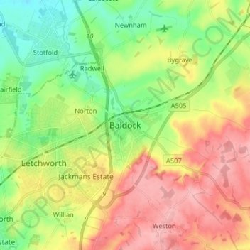
Nome: Mapa topográfico Baldock, altitude, relevo.
Altitude média: 90 m
Altitude mínima: 38 m
Altitude máxima: 152 m
Outros mapas topográficos
Clique em um mapa para visualizar sua topografia, sua altitude e seu relevo.
Royston
United Kingdom > England > Hertfordshire > North Hertfordshire
Royston, North Hertfordshire, Hertfordshire, England, United Kingdom
Altitude média: 78 m
Barkway
United Kingdom > England > Hertfordshire > North Hertfordshire
Barkway, North Hertfordshire, Hertfordshire, England, United Kingdom
Altitude média: 119 m
Letchworth
United Kingdom > England > Hertfordshire > North Hertfordshire > Letchworth
Letchworth, North Hertfordshire, Hertfordshire, East of England, England, SG6 3BF, United Kingdom
Altitude média: 80 m