
Mapa topográfico Turracher Höhe
Mapa interativo
Clique no mapa para exibir a altitude.
Turracher Höhe
The highest point of the approx. two km long pass summit has an altitude of 1,795 m above sea level south of the Turracher Lake. The lake has a water level of 1,763 m above sea (Adria) level and is connected to the village. The Turracher Höhe, as a "classic" pass summit, is also part of a drainage divide between the Mura valley and the Upper Gurk River, whose source is beneath the Lattersteighöhe at approx. 2,000 m above sea level.
Sobre este mapa
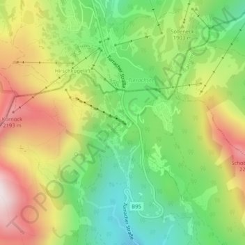
Nome: Mapa topográfico Turracher Höhe, altitude, relevo.
Altitude média: 1870 m
Altitude mínima: 1545 m
Altitude máxima: 2293 m