
Mapa topográfico Polatlı
Mapa interativo
Clique no mapa para exibir a altitude.
Sobre este mapa
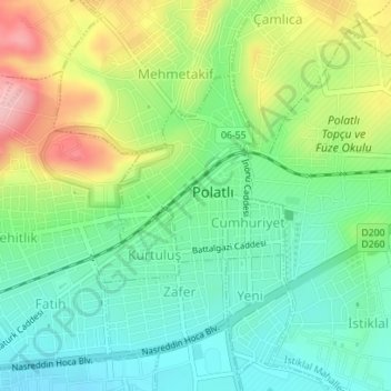
Nome: Mapa topográfico Polatlı, altitude, relevo.
Altitude média: 889 m
Altitude mínima: 833 m
Altitude máxima: 988 m
Polatlı (formerly Ancient Greek: Γόρδιον, Górdion and Latin: Gordium) is a city and a district in Ankara Province in the Central Anatolia region of Turkey, 80 km west of the Turkish capital Ankara, on the road to Eskişehir. According to 2019 census, population of the district is 125,075 of which 98,605 live in the city of Polatlı. The district covers an area of 3,789 km2, and the average elevation is 850 m.
Outros mapas topográficos
Clique em um mapa para visualizar sua topografia, sua altitude e seu relevo.
Karacaahmet
Karacaahmet, Polatlı, Ankara, Central Anatolia Region, Turkey
Altitude média: 683 m
Yassıhüyük
Yassıhüyük, Polatlı, Ankara, Central Anatolia Region, Turkey
Altitude média: 698 m