
Mapa topográfico Leemhorst
Mapa interativo
Clique no mapa para exibir a altitude.
Sobre este mapa
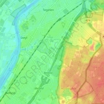
Nome: Mapa topográfico Leemhorst, altitude, relevo.
Altitude média: 30 m
Altitude mínima: 11 m
Altitude máxima: 56 m
Outros mapas topográficos
Clique em um mapa para visualizar sua topografia, sua altitude e seu relevo.
Maasveld I
Nederland > Limburg > Tegelen > Maasveld I
Maasveld I, Tegelen, Venlo, Limburg, Nederland, 5931SG, Nederland
Altitude média: 23 m
Maasveld II
Maasveld II, Tegelen, Venlo, Limburg, Nederland, 5931 TJ, Nederland
Altitude média: 24 m