
Mapa topográfico Mussoorie
Mapa interativo
Clique no mapa para exibir a altitude.
Sobre este mapa
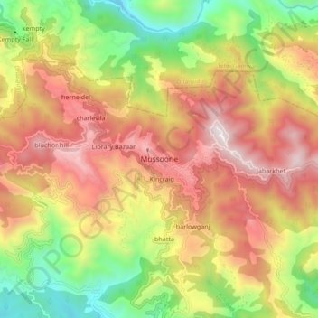
Nome: Mapa topográfico Mussoorie, altitude, relevo.
Local: Mussoorie, Dehradun, Uttarakhand, 248179, India (30.41690 78.03829 30.49690 78.11829)
Altitude média: 1594 m
Altitude mínima: 878 m
Altitude máxima: 2285 m
Mussoorie is at an average altitude of 2,005 metres (6,578 ft). To the northeast are the Himalayan snow ranges, and to the south, the Doon Valley and Shiwalik ranges. The second highest point is the original Lal Tibba in Landour, with a height of over 2,275 m (7,464 ft). Mussoorie is popularly known as The Queen of the Hills.
Outros mapas topográficos
Clique em um mapa para visualizar sua topografia, sua altitude e seu relevo.
Dehradun
India > Uttarakhand > Dehradun
Dehradun, Dehradun District, Uttarakhand, 248001, India
Altitude média: 904 m
Sahastradhara
India > Uttarakhand > Dehradun
Sahastradhara, Dehradun, Dehradun District, Uttarakhand, 248009, India
Altitude média: 1100 m
Mohanpur
India > Uttarakhand > Dehradun > Dehradun
Mohanpur, Dehradun, Dehradun District, Uttarakhand, 248001, India
Altitude média: 599 m
Doiwāla
India > Uttarakhand > Dehradun
Doiwāla, Dehradun, Uttarakhand, 248140, India
Altitude média: 485 m