
Mapa topográfico Diablo Lake
Mapa interativo
Clique no mapa para exibir a altitude.
Sobre este mapa
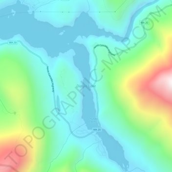
Nome: Mapa topográfico Diablo Lake, altitude, relevo.
Local: Diablo Lake, Whatcom County, Washington, United States (48.68160 -121.13257 48.72013 -121.08459)
Altitude média: 643 m
Altitude mínima: 362 m
Altitude máxima: 1538 m
Diablo Lake is a reservoir in the North Cascade mountains of northern Washington state, United States. Created by Diablo Dam, the lake is located between Ross Lake and Gorge Lake on the Skagit River at an elevation of 1,201 feet (366 m) above sea level. Diablo Lake is part of the Skagit River Hydroelectric Project and managed by Seattle City Light.
Outros mapas topográficos
Clique em um mapa para visualizar sua topografia, sua altitude e seu relevo.
Lummi Island
United States > Washington > Whatcom County
Lummi Island, Whatcom County, Washington, United States
Altitude média: 24 m
Ross Lake
United States > Washington > Whatcom County
Ross Lake, Whatcom County, Washington, United States
Altitude média: 1314 m
Bellingham
United States > Washington > Whatcom County
Bellingham, Whatcom County, Washington, United States
Altitude média: 89 m
Hampton
United States > Washington > Whatcom County
Hampton, Whatcom County, Washington, 98276, United States
Altitude média: 24 m
Custer
United States > Washington > Whatcom County
Custer, Whatcom County, Washington, 98240, United States
Altitude média: 20 m
Balford
United States > Washington > Whatcom County
Balford, Whatcom County, Washington, 98266, United States
Altitude média: 342 m
Acme
United States > Washington > Whatcom County
Acme, Whatcom County, Washington, 98220, United States
Altitude média: 420 m
Birch Bay
United States > Washington > Whatcom County
Birch Bay, Whatcom County, Washington, United States
Altitude média: 21 m
Point Roberts
United States > Washington > Whatcom County > Point Roberts
Point Roberts, Whatcom County, Washington, 98281, United States
Altitude média: 9 m
Ferndale
United States > Washington > Whatcom County > Ferndale
Ferndale, Whatcom County, Washington, 98248, United States
Altitude média: 29 m
Sudden Valley
United States > Washington > Whatcom County
Sudden Valley, Whatcom County, Washington, 98228, United States
Altitude média: 239 m
Ferndale
United States > Washington > Whatcom County
Ferndale, Whatcom County, Washington, United States
Altitude média: 29 m
Bellingham
United States > Washington > Whatcom County > Bellingham
Bellingham, Whatcom County, Washington, 98225-3243, United States
Altitude média: 129 m
Blaine
United States > Washington > Whatcom County > Blaine
Blaine, Whatcom County, Washington, United States
Altitude média: 23 m