
Mapa topográfico Stieldorf
Mapa interativo
Clique no mapa para exibir a altitude.
Sobre este mapa
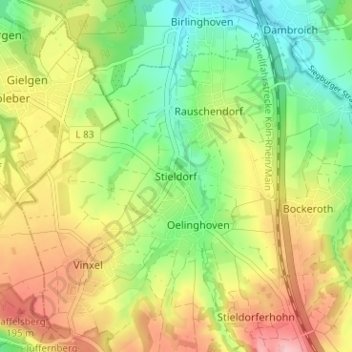
Nome: Mapa topográfico Stieldorf, altitude, relevo.
Altitude média: 143 m
Altitude mínima: 77 m
Altitude máxima: 224 m
Zum Stadtteil Stieldorf gehören die Ortsteile Bockeroth, Düferoth, Frankenforst, Freckwinkel, Friedrichshöhe, Heiderhof, Höhnerhof, Niederscheuren, Oberscheuren, Oelinghoven, Rauschendorf, Sonderbusch, Sonnenbergerhof, Stieldorf, Stieldorferhohn und Vinxel.