
Mapa topográfico Werlaburgdorf
Mapa interativo
Clique no mapa para exibir a altitude.
Sobre este mapa
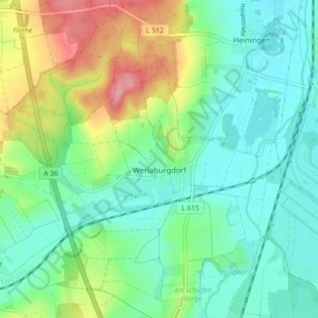
Nome: Mapa topográfico Werlaburgdorf, altitude, relevo.
Altitude média: 112 m
Altitude mínima: 79 m
Altitude máxima: 188 m
Outros mapas topográficos
Clique em um mapa para visualizar sua topografia, sua altitude e seu relevo.
Abbenrode
Germany > Lower Saxony > Landkreis Wolfenbüttel > Cremlingen
Abbenrode, Cremlingen, Landkreis Wolfenbüttel, Lower Saxony, Germany
Altitude média: 160 m
Veltheim
Germany > Lower Saxony > Landkreis Wolfenbüttel
Veltheim, Samtgemeinde Sickte, Landkreis Wolfenbüttel, Lower Saxony, Germany
Altitude média: 132 m
Werlaburgdorf
Germany > Lower Saxony > Landkreis Wolfenbüttel > Werlaburgdorf
Werlaburgdorf, Landkreis Wolfenbüttel, Lower Saxony, 38315, Germany
Altitude média: 111 m
Elbe
Germany > Lower Saxony > Landkreis Wolfenbüttel
Elbe, Samtgemeinde Baddeckenstedt, Landkreis Wolfenbüttel, Lower Saxony, 38274, Germany
Altitude média: 142 m