
Mapa topográfico Village of Tannersville
Mapa interativo
Clique no mapa para exibir a altitude.
Sobre este mapa
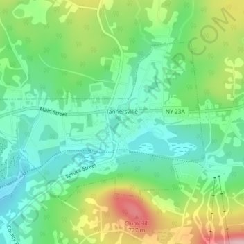
Nome: Mapa topográfico Village of Tannersville, altitude, relevo.
Altitude média: 613 m
Altitude mínima: 547 m
Altitude máxima: 742 m
Tannersville is located in southern Greene County at 42°11′37″N 74°8′20″W / 42.19361°N 74.13889°W / 42.19361; -74.13889 (42.193619, -74.139011), in the northern part of the town of Hunter. It is situated at an elevation of 1,900 feet (580 m) in the Catskill Mountains just west of the height of land on New York State Route 23A: Sawmill Creek flows southwest through the center of the village into Gooseberry Creek and thence into Schoharie Creek, a north-flowing tributary of the Mohawk River, while just 2 miles (3 km) to the east, at Haines Falls, Kaaterskill Creek drops east into Kaaterskill Clove and thence into the Hudson River valley.
Outros mapas topográficos
Clique em um mapa para visualizar sua topografia, sua altitude e seu relevo.
Sugarloaf Mountain
United States > New York > Greene County > Town of Hunter
Sugarloaf Mountain, Town of Hunter, Greene County, New York, United States
Altitude média: 846 m