
Mapa topográfico Mount Elbrus (West Summit)
Mapa interativo
Clique no mapa para exibir a altitude.
Sobre este mapa
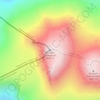
Nome: Mapa topográfico Mount Elbrus (West Summit), altitude, relevo.
Altitude média: 5161 m
Altitude mínima: 4565 m
Altitude máxima: 5632 m
As Elbrus is located in the Northern Hemisphere, the summer period takes place from June to mid-September, with an average of 50% of sunny days favorable to the ascent of the summit. However, the winds, dominated by westerly air masses, can turn violent and temperatures drop very quickly. Above 4000 meters above sea level, even in summer, blizzard conditions with near zero visibility can develop. It is not uncommon for the wind to exceed 100 km/h. In winter, the temperature can drop below −50° at the top. Precipitation increases with altitude.
Outros mapas topográficos
Clique em um mapa para visualizar sua topografia, sua altitude e seu relevo.
Западное ребро
Russia > Karachay-Cherkessia > Karachayevsky District
Западное ребро, Хурзукское сельское поселение, Karachayevsky District, Karachay-Cherkessia, North Caucasian Federal District, Russia
Altitude média: 5130 m
Западное ребро
Russia > Karachay-Cherkessia > Karachayevsky District
Западное ребро, Хурзукское сельское поселение, Karachayevsky District, Karachay-Cherkessia, North Caucasian Federal District, Russia
Altitude média: 5092 m