
Mapa topográfico Methven
Mapa interativo
Clique no mapa para exibir a altitude.
Sobre este mapa
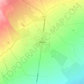
Nome: Mapa topográfico Methven, altitude, relevo.
Local: Methven, Ashburton District, Canterbury, 7730, New Zealand (-43.67243 171.60726 -43.59243 171.68726)
Altitude média: 322 m
Altitude mínima: 270 m
Altitude máxima: 396 m
Methven (Māori: Piwakawaka) is a small town in the Canterbury region of the South Island of New Zealand. It is located near the western edge of the Canterbury Plains, 35 km (22 mi) north of Ashburton and 95 km (59 mi) west of Christchurch, and at an elevation of 320 m (1,050 ft). The town is a service centre for agriculture in the surrounding area, and is a base for skiing at the nearby Mount Hutt skifield. The town slogan is "Amazing Space".
Outros mapas topográficos
Clique em um mapa para visualizar sua topografia, sua altitude e seu relevo.
Mount Sunday
New Zealand > Canterbury > Ashburton District
Mount Sunday, Ashburton District, Canterbury, New Zealand
Altitude média: 547 m
Mount Alford
New Zealand > Canterbury > Ashburton District
Mount Alford, Ashburton District, Canterbury, New Zealand
Altitude média: 806 m
Wheatstone
New Zealand > Canterbury > Ashburton District
Wheatstone, Ashburton District, Canterbury, New Zealand
Altitude média: 47 m
Ashburton
New Zealand > Canterbury > Ashburton District > Ashburton
Ashburton, Ashburton District, Canterbury, 7700, New Zealand
Altitude média: 99 m