
Mapa topográfico Weikering
Mapa interativo
Clique no mapa para exibir a altitude.
Sobre este mapa
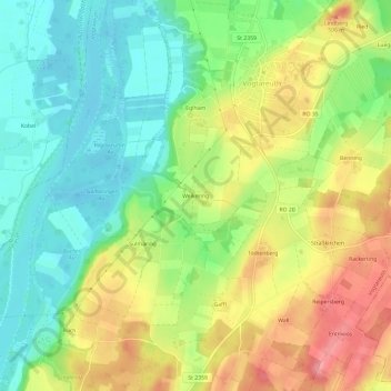
Nome: Mapa topográfico Weikering, altitude, relevo.
Altitude média: 470 m
Altitude mínima: 426 m
Altitude máxima: 530 m
Outros mapas topográficos
Clique em um mapa para visualizar sua topografia, sua altitude e seu relevo.
Untersee
Deutschland > Bayern > Landkreis Rosenheim > Vogtareuth
Untersee, Vogtareuth, Landkreis Rosenheim, Bayern, 83134, Deutschland
Altitude média: 500 m