
Faça uma doação
Prepare-se para a sua próxima aventura:
Como Associado da Amazon, este site recebe uma comissão sobre compras elegíveis sem custo adicional para si.
Mapa topográfico Noorabad
Clique no mapa para exibir a altitude.
Faça uma doação
Prepare-se para a sua próxima aventura:
Como Associado da Amazon, este site recebe uma comissão sobre compras elegíveis sem custo adicional para si.
Sobre este mapa
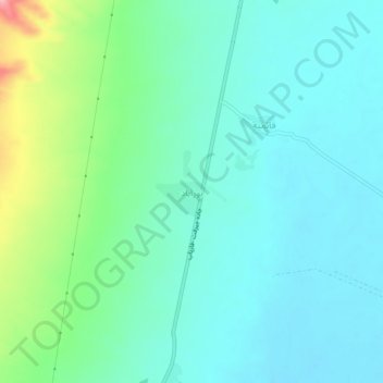
Nome: Mapa topográfico Noorabad, altitude, relevo.
Local: Noorabad, بخش اسماعیلی, Jiroft County, Kerman Province, Iran (28.36003 57.69911 28.40003 57.73911)
Altitude média: 570 m
Altitude mínima: 538 m
Altitude máxima: 679 m
Faça uma doação
Prepare-se para a sua próxima aventura:
Como Associado da Amazon, este site recebe uma comissão sobre compras elegíveis sem custo adicional para si.
Outros mapas topográficos
Clique em um mapa para visualizar sua topografia, sua altitude e seu relevo.
Jiroft
Iran > Kerman Province > Jiroft County
Jiroft is in a vast plain, Halil River, on the southern outskirts of the Jebal Barez mountain chain, surrounded by two rivers. The mean elevation of the city is about 650 metres (2,130 ft) above sea level. The weather of the city is sweltering in summer – it is one of the hottest places in Iran – but…
Altitude média: 692 m
Jiroft
Iran > Kerman Province > Jiroft County
Jiroft lies in an alluvial plain of the Halil River, on the southern outskirts of the Jebal Barez mountain chain. It sits in a tectonically active basin, at the northern end of the Bandar Abbas-Jiroft fault zone, with both structural and anthropogenic subsidence occurring. Two intermittent streams join the…
Altitude média: 695 m