
Mapa topográfico West Schuyler
Mapa interativo
Clique no mapa para exibir a altitude.
Sobre este mapa
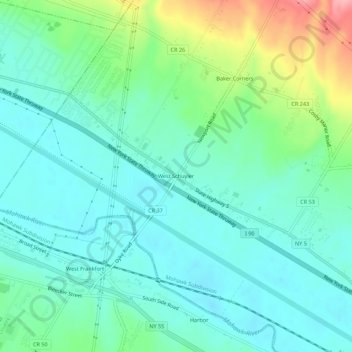
Nome: Mapa topográfico West Schuyler, altitude, relevo.
Altitude média: 144 m
Altitude mínima: 113 m
Altitude máxima: 235 m
Outros mapas topográficos
Clique em um mapa para visualizar sua topografia, sua altitude e seu relevo.
North Frankfort
United States > New York > Herkimer County > Town of Schuyler
North Frankfort, Town of Schuyler, Herkimer County, New York, 13357, United States
Altitude média: 177 m
Johnson Corners
United States > New York > Herkimer County > Town of Schuyler
Johnson Corners, Town of Schuyler, Herkimer County, New York, United States
Altitude média: 230 m
Baker Corners
United States > New York > Herkimer County > Town of Schuyler
Baker Corners, Town of Schuyler, Herkimer County, New York, 13504, United States
Altitude média: 181 m
East Schuyler
United States > New York > Herkimer County > Town of Schuyler
East Schuyler, Town of Schuyler, Herkimer County, New York, 13340, United States
Altitude média: 159 m