
Mapa topográfico Ticehurst
Mapa interativo
Clique no mapa para exibir a altitude.
Sobre este mapa
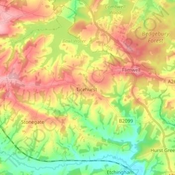
Nome: Mapa topográfico Ticehurst, altitude, relevo.
Local: Ticehurst, Rother, East Sussex, England, United Kingdom (51.00962 0.34657 51.08365 0.47187)
Altitude média: 81 m
Altitude mínima: 13 m
Altitude máxima: 154 m
Outros mapas topográficos
Clique em um mapa para visualizar sua topografia, sua altitude e seu relevo.
Bexhill-on-Sea
United Kingdom > England > East Sussex > Rother
Bexhill-on-Sea, Rother, East Sussex, England, TN39 3PE, United Kingdom
Altitude média: 13 m
Battle
United Kingdom > England > East Sussex > Rother > Battle
Battle, Rother, East Sussex, South East England, England, United Kingdom
Altitude média: 66 m
Burwash
United Kingdom > England > East Sussex > Rother
Burwash, Rother, East Sussex, England, TN19 7EP, United Kingdom
Altitude média: 56 m