
Mapa topográfico Hanley
Clique no mapa para exibir a altitude.
Sobre este mapa
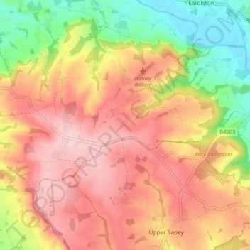
Nome: Mapa topográfico Hanley, altitude, relevo.
Local: Hanley, Malvern Hills, Worcestershire, England, United Kingdom (52.27409 -2.53556 52.30256 -2.45476)
Altitude média: 158 m
Altitude mínima: 38 m
Altitude máxima: 247 m
Outros mapas topográficos
Clique em um mapa para visualizar sua topografia, sua altitude e seu relevo.
Upper Broadheath
United Kingdom > England > Worcestershire > Malvern Hills > Crown East
Altitude média: 44 m
Malvern
United Kingdom > England > Worcestershire > Malvern Hills
Malvern lies in the Lower Severn/Avon plain affording it a degree of shelter caused by virtue of its nestling in between the Cotswold hills to the east, the Welsh Hills and Mountains to the west, and Birmingham plateau to the north. Although as with all the British Isles it has a maritime climate, the local…
Altitude média: 95 m
Kerswell Green
United Kingdom > England > Worcestershire > Malvern Hills > Kempsey
Altitude média: 25 m
Corse Lawn
United Kingdom > England > Worcestershire > Malvern Hills > Eldersfield
Altitude média: 26 m
The Hill, Abberley
United Kingdom > England > Worcestershire > Malvern Hills > Abberley
Altitude média: 132 m
Table Hill
United Kingdom > England > Worcestershire > Malvern Hills
Table Hill is situated in the range of Malvern Hills that runs about 13 kilometres (8 mi) north-south along the Herefordshire-Worcestershire border. It lies between North Hill and Sugarloaf Hill and has an elevation of 373 metres (1,224 ft).
Altitude média: 188 m
Malvern
United Kingdom > England > Worcestershire > Malvern Hills
Malvern lies in the Lower Severn/Avon plain affording it a degree of shelter caused by virtue of its nestling in between the Cotswold hills to the east, the Welsh Hills and Mountains to the west, and Birmingham plateau to the north. Although as with all the British Isles it has a maritime climate, the local…
Altitude média: 95 m