
Mapa topográfico Donoughmore
Mapa interativo
Clique no mapa para exibir a altitude.
Sobre este mapa
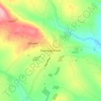
Nome: Mapa topográfico Donoughmore, altitude, relevo.
Altitude média: 183 m
Altitude mínima: 119 m
Altitude máxima: 272 m
Outros mapas topográficos
Clique em um mapa para visualizar sua topografia, sua altitude e seu relevo.
Kilnamartery
Ireland > County Cork > Municipal District of Macroom
Kilnamartery, Municipal District of Macroom, County Cork, Munster, Ireland
Altitude média: 118 m
Iniscarra Dam View
Ireland > County Cork > Municipal District of Macroom
Iniscarra Dam View, L5228, Ovens, Municipal District of Macroom, County Cork, Munster, P31 TX39, Ireland
Altitude média: 83 m
Monallig
Ireland > County Cork > Municipal District of Macroom
Monallig, Cannaway ED, Municipal District of Macroom, County Cork, Munster, Ireland
Altitude média: 90 m
Drominahilla
Ireland > County Cork > Municipal District of Macroom
Drominahilla, Drishane, Municipal District of Macroom, County Cork, Munster, Ireland
Altitude média: 127 m
Macroom
Ireland > County Cork > Municipal District of Macroom
Macroom, Municipal District of Macroom, County Cork, Munster, Ireland
Altitude média: 210 m
Loughane East
Ireland > County Cork > Municipal District of Macroom
Loughane East, Matehy, Municipal District of Macroom, County Cork, Munster, Ireland
Altitude média: 98 m