
Mapa topográfico Oberhartheim
Mapa interativo
Clique no mapa para exibir a altitude.
Sobre este mapa
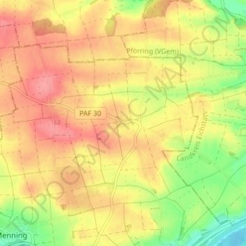
Nome: Mapa topográfico Oberhartheim, altitude, relevo.
Altitude média: 394 m
Altitude mínima: 346 m
Altitude máxima: 428 m
Outros mapas topográficos
Clique em um mapa para visualizar sua topografia, sua altitude e seu relevo.
Knodorf
Deutschland > Bayern > Landkreis Pfaffenhofen an der Ilm > Vohburg an der Donau
Knodorf, Vohburg an der Donau, Landkreis Pfaffenhofen an der Ilm, Bayern, 85119, Deutschland
Altitude média: 360 m
Pleiling
Deutschland > Bayern > Landkreis Pfaffenhofen an der Ilm > Vohburg an der Donau > Pleiling
Pleiling, Vohburg an der Donau, Landkreis Pfaffenhofen an der Ilm, Bayern, 85129, Deutschland
Altitude média: 400 m