
Mapa topográfico Simpelveld
Mapa interativo
Clique no mapa para exibir a altitude.
Sobre este mapa
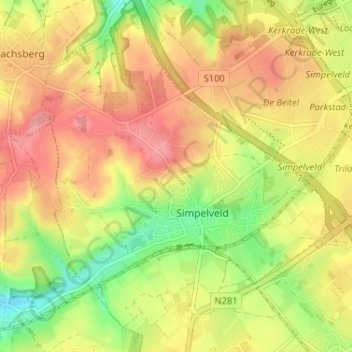
Nome: Mapa topográfico Simpelveld, altitude, relevo.
Local: Simpelveld, Limburg, Nederland (50.81942 5.95325 50.86023 6.00540)
Altitude média: 172 m
Altitude mínima: 117 m
Altitude máxima: 217 m
Outros mapas topográficos
Clique em um mapa para visualizar sua topografia, sua altitude e seu relevo.
Molsberg
Nederland > Limburg > Simpelveld
Molsberg, Simpelveld, Limburg, Nederland, 6369 GP, Nederland
Altitude média: 172 m
Bosschenhuizen
Nederland > Limburg > Simpelveld
Bosschenhuizen, Simpelveld, Limburg, Nederland, 6369 BK, Nederland
Altitude média: 171 m
Huls
Nederland > Limburg > Simpelveld
Huls, Simpelveld, Limburg, Nederland, 6369 ET, Nederland
Altitude média: 172 m
In de Gaas
Nederland > Limburg > Simpelveld > In de Gaas
In de Gaas, Simpelveld, Limburg, Nederland, 6369VA, Nederland
Altitude média: 172 m