
Mapa topográfico Eerste River
Mapa interativo
Clique no mapa para exibir a altitude.
Sobre este mapa
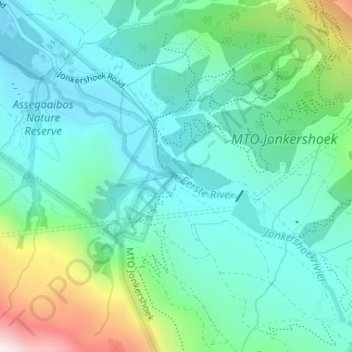
Nome: Mapa topográfico Eerste River, altitude, relevo.
Altitude média: 372 m
Altitude mínima: 206 m
Altitude máxima: 912 m
Outros mapas topográficos
Clique em um mapa para visualizar sua topografia, sua altitude e seu relevo.
Hottentots-Holland Nature Reserve
RSA > Western Cape > Stellenbosch Local Municipality
Hottentots-Holland Nature Reserve, Boegoekloof, Stellenbosch Ward 5, Stellenbosch Local Municipality, Overberg District Municipality, Western Cape, RSA
Altitude média: 557 m
Klapmutskop
RSA > Western Cape > Stellenbosch Local Municipality
Klapmutskop, Stellenbosch Local Municipality, Cape Winelands District Municipality, Western Cape, 7607, RSA
Altitude média: 261 m
Mount Rochelle Nature Reserve
RSA > Western Cape > Stellenbosch Local Municipality
Mount Rochelle Nature Reserve, R45, Stellenbosch Ward 1, Stellenbosch Local Municipality, Cape Winelands District Municipality, Western Cape, 7690, RSA
Altitude média: 844 m