
Mapa topográfico Washington, D.C.
Mapa interativo
Clique no mapa para exibir a altitude.
Sobre este mapa
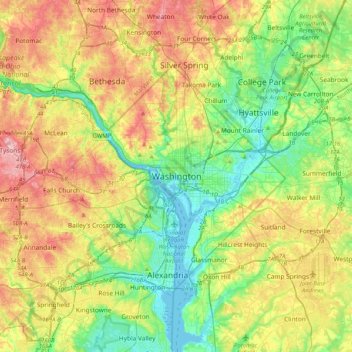
Nome: Mapa topográfico Washington, D.C., altitude, relevo.
Altitude média: 63 m
Altitude mínima: -2 m
Altitude máxima: 161 m
The highest natural elevation in the District is 409 feet (125 m) above sea level at Fort Reno Park in upper northwest Washington. The lowest point is sea level at the Potomac River. The geographic center of Washington is near the intersection of 4th and L Streets NW.