
Mapa topográfico Montalvânia
Mapa interativo
Clique no mapa para exibir a altitude.
Sobre este mapa
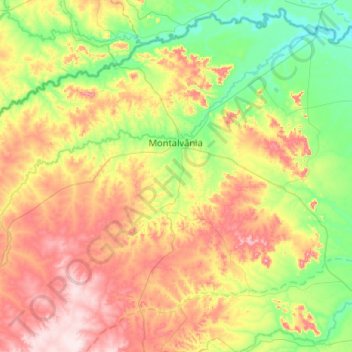
Nome: Mapa topográfico Montalvânia, altitude, relevo.
Altitude média: 585 m
Altitude mínima: 444 m
Altitude máxima: 808 m
Montalvânia is a municipality in the northernmost point of the state of Minas Gerais in Brazil. As of 2008 the population was 16,265 in an area of 1,484.388 km². The elevation of the municipal seat is 510 meters, the postal code (CEP) is 39495-000 and it is located in the microregion of Januária