Mapa topográfico La Bretagne
Mapa interativo
Clique no mapa para exibir a altitude.
Sobre este mapa
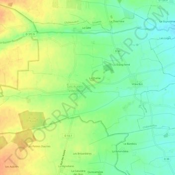
Nome: Mapa topográfico La Bretagne, altitude, relevo.
Altitude média: 195 m
Altitude mínima: 177 m
Altitude máxima: 215 m

Clique no mapa para exibir a altitude.
Nome: Mapa topográfico La Bretagne, altitude, relevo.
Altitude média: 195 m
Altitude mínima: 177 m
Altitude máxima: 215 m