
Mapa topográfico Mount Mitchell
Mapa interativo
Clique no mapa para exibir a altitude.
Sobre este mapa
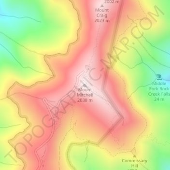
Nome: Mapa topográfico Mount Mitchell, altitude, relevo.
Local: Mount Mitchell, Yancey County, North Carolina, United States (35.76491 -82.26517 35.76501 -82.26507)
Altitude média: 1743 m
Altitude mínima: 1355 m
Altitude máxima: 2019 m
Mount Mitchell, known in Cherokee as Attakulla, is the highest peak of the Appalachian Mountains and the highest peak in mainland eastern North America. It is located near Burnsville in Yancey County, North Carolina in the Black Mountain subrange of the Appalachians about 19 miles (31 km) northeast of Asheville. It is protected by Mount Mitchell State Park and surrounded by the Pisgah National Forest. Mount Mitchell's elevation is 6,684 feet (2,037 m) above sea level.
Outros mapas topográficos
Clique em um mapa para visualizar sua topografia, sua altitude e seu relevo.
Appalachian Mountains
United States > North Carolina > Yancey County
Appalachian Mountains, Yancey County, North Carolina, United States
Altitude média: 1463 m
Burnsville
United States > North Carolina > Yancey County
Burnsville, Yancey County, North Carolina, United States
Altitude média: 882 m
Mitchell Ridge
United States > North Carolina > Yancey County
Mitchell Ridge, Yancey County, North Carolina, United States
Altitude média: 1517 m
Cane River
United States > North Carolina > Yancey County > Low Gap
Cane River, Low Gap, Yancey County, North Carolina, 28714, United States
Altitude média: 944 m
Cane River
United States > North Carolina > Yancey County > Eskota
Cane River, Eskota, Yancey County, North Carolina, United States
Altitude média: 1154 m
Lost Cove
United States > North Carolina > Yancey County > Lost Cove
Lost Cove, Yancey County, North Carolina, United States
Altitude média: 852 m