
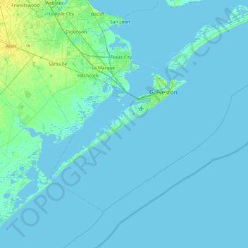
Mapa topográfico Galveston Island
Mapa interativo
Clique no mapa para exibir a altitude.
Sobre este mapa
Nome: Mapa topográfico Galveston Island, altitude, relevo.
Altitude média: 2 m
Altitude mínima: -4 m
Altitude máxima: 23 m
Outros mapas topográficos
Clique em um mapa para visualizar sua topografia, sua altitude e seu relevo.
Galveston
United States > Texas > Galveston County > Galveston
Galveston, Galveston County, Texas, 77553, United States
Altitude média: 1 m
Campeche Cove
United States > Texas > Galveston County > Galveston > Campeche Cove
Campeche Cove, Galveston, Galveston County, Texas, 77552, United States
Altitude média: 2 m