
Mapa topográfico Eagle Mountain
Mapa interativo
Clique no mapa para exibir a altitude.
Sobre este mapa
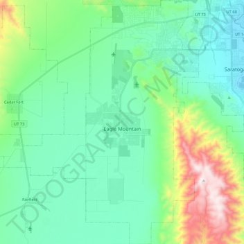
Nome: Mapa topográfico Eagle Mountain, altitude, relevo.
Local: Eagle Mountain, Utah County, Utah, 84005, United States (40.23225 -112.13010 40.39496 -111.94501)
Altitude média: 1589 m
Altitude mínima: 1366 m
Altitude máxima: 2339 m
Eagle Mountain's climate varies drastically between the northeastern Ranches area and the southwestern City Center area. Despite being further south than Salt Lake City, both areas have cooler temperatures due to sitting at a higher elevation. The Ranches section of the city has slightly milder temperatures since it is closer to the moderating impact of the Salt Lake and Utah Valleys as well as the Great Salt Lake, which gives it a climate more similar to Salt Lake City. The City Center area near Fairfield lies in the Cedar Valley, which cuts that area off from the moderating influence of the Salt Lake Valley and Great Salt lake. This causes nights to get significantly colder than in the Ranches but also puts it in a rain shadow causing less precipitation and more sunshine than the Ranches part of the city.
Outros mapas topográficos
Clique em um mapa para visualizar sua topografia, sua altitude e seu relevo.
Provo
United States > Utah > Utah County
Provo, Utah County, Utah, United States
Altitude média: 1728 m
Woodland Hills
United States > Utah > Utah County
Woodland Hills, Utah County, Utah, United States
Altitude média: 1812 m
Saratoga Springs
United States > Utah > Utah County
Saratoga Springs, Utah County, Utah, 84045, United States
Altitude média: 1500 m
Mount Timpanogos
United States > Utah > Utah County
Mount Timpanogos, Utah County, Utah, 84602, United States
Altitude média: 3139 m
Elk Ridge
United States > Utah > Utah County
Elk Ridge, Utah County, Utah, United States
Altitude média: 1698 m
Townsend
United States > Utah > Utah County > Genola
Townsend, Genola, Utah County, Utah, 84655, United States
Altitude média: 1438 m
Pleasant View
United States > Utah > Utah County > Provo
Pleasant View, Provo, Utah County, Utah, 84604, United States
Altitude média: 1446 m
Salem
United States > Utah > Utah County
Salem, Utah County, Utah, 84653, United States
Altitude média: 1473 m
Lehi
United States > Utah > Utah County
Lehi, Utah County, Utah, 84043, United States
Altitude média: 1465 m
Lone Peak
United States > Utah > Utah County
Lone Peak, Utah County, Utah, 84092, United States
Altitude média: 3013 m
Springville
United States > Utah > Utah County
Springville, Utah County, Utah, 84663, United States
Altitude média: 1566 m
Pleasant Grove
United States > Utah > Utah County
Pleasant Grove, Utah County, Utah, 84062, United States
Altitude média: 1578 m
Vineyard
United States > Utah > Utah County
Vineyard, Utah County, Utah, 84059, United States
Altitude média: 1382 m
Santaquin
United States > Utah > Utah County > Santaquin
Santaquin, Utah County, Utah, 84655, United States
Altitude média: 1701 m
Lindon
United States > Utah > Utah County
Lindon, Utah County, Utah, 84042, United States
Altitude média: 1537 m
Payson
United States > Utah > Utah County > Payson
Payson, Utah County, Utah, 84651, United States
Altitude média: 1473 m