
Mapa topográfico Dublin Castle
Mapa interativo
Clique no mapa para exibir a altitude.
Sobre este mapa
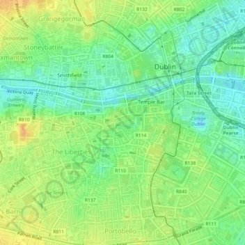
Nome: Mapa topográfico Dublin Castle, altitude, relevo.
Altitude média: 16 m
Altitude mínima: 1 m
Altitude máxima: 32 m
The Poddle was diverted into the city through archways where the walls adjoined the castle, artificially flooding the moat of the fortress's city elevations. One of these archways and part of the wall survive buried underneath the 18th-century buildings, and are open for public viewing.
Outros mapas topográficos
Clique em um mapa para visualizar sua topografia, sua altitude e seu relevo.
Priorswood
Ireland > County Dublin > Dublin
Priorswood, Priorswood E Ward 1986, Dublin, County Dublin, Leinster, D17 XV48, Ireland
Altitude média: 42 m
Liberty of Donore
Ireland > County Dublin > Dublin
Liberty of Donore, Kimmage C Ward 1986, Dublin, County Dublin, Leinster, Ireland
Altitude média: 27 m
Darndale
Ireland > County Dublin > Dublin
Darndale, Priorswood C Ward 1986, Dublin, County Dublin, Leinster, Ireland
Altitude média: 35 m
Bluebell
Ireland > County Dublin > Dublin
Bluebell, Inchicore B Ward 1986, Dublin, County Dublin, Leinster, Ireland
Altitude média: 44 m
Ballygall
Ireland > County Dublin > Dublin
Ballygall, Finglas East D ED, Dublin, County Dublin, Leinster, Ireland
Altitude média: 53 m
Dublin
Ireland > County Dublin > Dublin
Dublin, Dún Laoghaire-Rathdown, County Dublin, Leinster, Ireland
Altitude média: 23 m
Sandymount
Ireland > County Dublin > Dublin
Sandymount, Pembroke East C ED, Dublin, County Dublin, Leinster, Ireland
Altitude média: 5 m
Santry
Ireland > County Dublin > Dublin
Santry, Whitehall C ED, Dublin, County Dublin, Leinster, Ireland
Altitude média: 54 m
Glasnevin
Ireland > County Dublin > Dublin
Glasnevin, Glasnevin A ED, Dublin, County Dublin, Leinster, D09 YN97, Ireland
Altitude média: 33 m
North Bull Island
Ireland > County Dublin > Dublin
North Bull Island, Raheny St. Assam ED, Dublin, County Dublin, Leinster, Ireland
Altitude média: 2 m
Rathgar
Ireland > County Dublin > Dublin
Rathgar, Rathfarnham A ED, Dublin, County Dublin, Leinster, Ireland
Altitude média: 40 m
Santry
Ireland > County Dublin > Dublin
Santry, Dublin, Fingal, County Dublin, Leinster, Ireland
Altitude média: 49 m
Belcamp
Ireland > County Dublin > Dublin
Belcamp, Priorswood B ED, Dublin, County Dublin, Leinster, Ireland
Altitude média: 37 m
Clonmel
Ireland > County Dublin > Dublin
Clonmel, Ballymun E ED, Dublin, County Dublin, Leinster, Ireland
Altitude média: 57 m
Rathmines
Ireland > County Dublin > Dublin
Rathmines, Rathmines West B ED, Dublin, County Dublin, Leinster, Ireland
Altitude média: 28 m
Walkinstown
Ireland > County Dublin > Dublin
Walkinstown, Walkinstown B Ward 1986, Dublin, County Dublin, Leinster, Ireland
Altitude média: 49 m
Donnycarney
Ireland > County Dublin > Dublin
Donnycarney, Drumcondra North A ED, Dublin, County Dublin, Leinster, Ireland
Altitude média: 24 m
Terenure
Ireland > County Dublin > Dublin
Terenure, Rathfarnham A ED, Dublin, County Dublin, Leinster, D06 K767, Ireland
Altitude média: 45 m
Irishtown
Ireland > County Dublin > Dublin
Irishtown, Pembroke East A ED, Dublin, County Dublin, Leinster, Ireland
Altitude média: 5 m